Summiting Mount Saint Helens

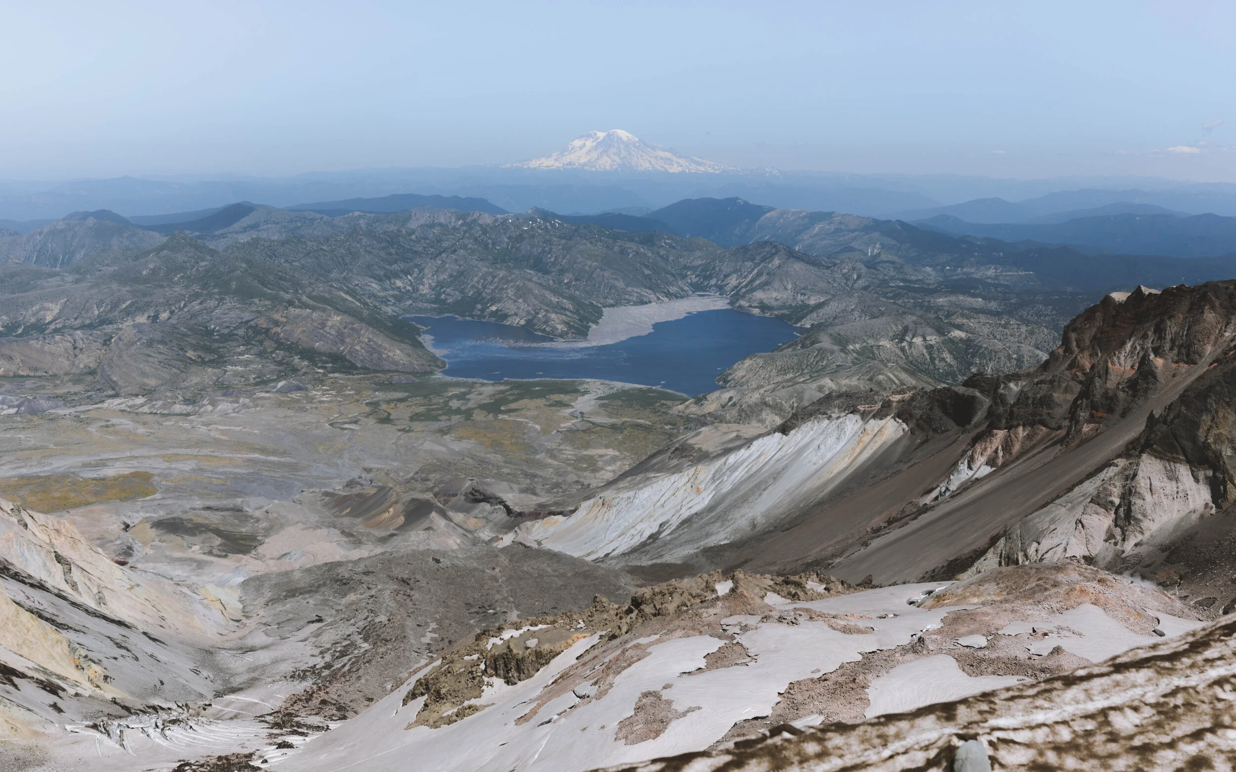
First, let me start by sharing some background history of this beautiful monument! Mount Saint Helens is an active stratovolcano located in Skamania County, Washington. The major eruption took place on May 19th in 1980 taking the lives of fifty-seven people, thousands of animals, 250 homes, 47 bridges, 15 miles (24 km) of railways and 185 miles (28 km) of highways. It was one of the deadliest, most economically destructive events in US history. The eruption reduced the summit from 9,677 ft (2,950 m) to 8,363 ft (2,549 m), leaving a 1 mile (1,6 km) wide crater.
This is considered a non technical mountaineer’s summit with two different trails; Monitor Ridge also known as the Ptarmigan trail best used spring, summer and early fall and then there’s the Worm Flows route used in the winter.
Monitor ridge/Ptarmigan Trail is 4.1 miles (6.5 km) to the summit with 4,583 ft (1,396 m) of elevation gain.
Worm Flows Trail is about 4.8 miles (7.7 km) to the summit with 5,577 ft (1,699 m) of elevation gain.
There are a few things you need before you can summit this mountain!
Climbing Permit (Needed April-October and I recommend getting this months in advance!)
-$15/person + $6 reservation fee
-April 1st - May 14th the summit is limited to 500 people a day
-May 14th - October 31st the summit is limited to 100 people a day
-November 1st - March 31st the amount of people that can summit is unlimited
Climbing Permits can be purchased by clicking here and if you would like additional information or want to check the current conditions click here.
Climber’s Registration
-Required year round when climbing above 4,800 ft (1,463 m)
-Where to acquire: In-person, self-register at the Climbers Bivouac or Marble Mountain Sno-park.
Northwest Forest Pass
-Required year round
-Day pass: $5
-Annual pass: $30
You can acquire this in person at a Forest Service office in the Pacific Northwest, your local REI or online here.
Sno-Park Permit
-Required for parking December 1st - April 30th
-Cost varies $20 - $42
For more information and where to acquire this pass, click here.
A few things to consider when choosing a time to climb is if you prefer to hike on snow or rocks, an isolated or popular route, do you want to carry more or less and are you prepared for the weather?

An app that I love to use for hiking, backpacking and sometimes summiting is AllTrails.
This is my go to app for the outdoors because you can find so many trails, download the maps to use offline, see reviews from other hikers, check the weather and see information regarding the miles/km and elevation gain.
You can find the directions to either trailhead on the app!
This Summit may not be the most technical however it is not a hike to underestimate! To do this hike you need to be in good physical shape and also comfortable scrambling on steep terrain. To get ready you should be doing other hikes with elevation gains around 3,000 ft (914 m) to 5,000 ft (1524 m) in about 4 miles to simulate the incline of Mt. St. Helens.
Here is a list of hikes you can use to train:
-Dog Mountain
-Starwar Trail
-McNeil Point
-Table Mountain via Aldrich Butte
-Huckleberry Mountain
-Bonanza Trail
-Angels Rest to Devils Rest Loop
-Mount Defiance
Things I brought for the summer summit:

Since I was hiking in the Summer (July), these are the items I used:
(ALWAYS, always check the weather conditions and see what other hikers say. The items you need will determine on the weather and can be different regardless of the season. If you’re experienced and well trained, it should take about 4-6 hours to summit and about 2-3 hours to get down. )
-35 liter backpack (could probably use a smaller one however I had camera gear with me, not pictured)
-3 liter camelback bladder (Also, hydrate well before the climb! Try to drink at least 1-2 liters of water before and you’ll notice a huge difference in your performance.)
- Lots of food (Eat before, during and after your climb! For more long lasting energy during the climb, load up on fats and protein before. Snack on foods high in carbohydrates during for quick bursts of energy and after, eat something high in fat and protein to help the muscles recover.)
-Utensils, pot, napkin
-MSR fuel, pocket rocket and lighter
-Trekking poles
-Sunscreen and sunscreen chapstick
-Sunglasses (Bring sunglasses with more sun coverage like these!)
-Hat (Bring a hat with more sun protection like this!)
-First aid kit
-Emergency bivy
-Head lamp
-Micro spikes
-Gloves
One item I didn’t bring that I really wished I had were gaiters!
I didn’t think about the small volcanic rocks getting in my shoes but they did and a lot of them too! I had to take my shoes off two different times to shake the rocks out.
Although I am an experienced hiker and climber, it took me about 5 hours to reach the summit and about 3 hours to get down. I also stayed at the top for about 2 hours taking in the views and fueling up on food-to give you an idea of what your itinerary might look like. Start the hike early!

For the winter you will need more equipment along with the knowledge on how to use the listed equipment:
(In the winter, the route can take about 10-14 hours roundtrip.)
-Ice axe
-Crampons
-Shelter
-Beacon
-Backcountry Access Tracker/ Transceiver
-Probe
-Shovel
-Avalanche backpack
-Navigation
-Skis with climbing skins (optional)
-Snow shoes with cleats (optional)
It is important to plan ahead in case of an emergency situation. Make sure to tell a family member or friend that is not climbing.
Details & Plan:
- Route you’re taking
-Estimated timeline
-Full names of everyone climbing with you
-When you expect to check back in
-When to initiate a search
-Search and rescue contact information
All in all, this was an incredible hike and the views were well worth the effort put in to reach the summit.

Views of Mount Adams on the way up to the summit.